The March 2019 update of ArcGIS Online brings new ways to find, analyse and share GIS content. There are also administrative enhancements and a new look to the sign-in screen. Here are some of the key features.
Finding, sharing and creating content
An interactive map can be a good way to understand what data is available for an area of interest, but searching the Content view might be more direct with the new option to filter the listed items by Location:
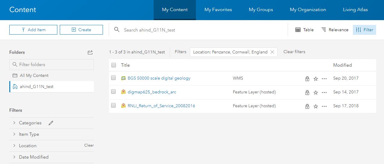
To get the most out of this, item owners must set the item's extent, or geographic boundaries. In another nice enhancement to searching for content, users are now given suggestions with partially entered keywords.
Groups are an important mechanism in ArcGIS Online - for managing access and organising content. Often users will be looking for maps or apps, rather than layers. With this update group owners and managers can specify an item type to display on the Overview and Content tab of the group page.
The Category Gallery (introduced in beta at the last release) is a really configurable way of setting up content galleries that support filtering on a range of options, including categories. You can also configure them to only show certain content types.
Some of our customers run ArcGIS Online alongside their ArcGIS Enterprise deployment, using Distributed Collaboration to synchronise data. They can now share Hosted Feature Layer Views and Insights Workbooks through this.
Access to the Create Watersheds, Create Viewshed and Trace Downstream has changed and the tools no longer cost credits to run.
Geotagged photos can be loaded into ArcGIS, but imagine if you could just upload a zip file into ArcGIS Online and have them appear as a point feature layer with the images as attachments... well you can now. If you have geotagged JPEG files, you just have to use Add Item and follow the dialogue - remembering to choose Photos with locations in the Contents option - and that's it.
An interesting new app interface
For many audiences the legend is an essential visual reference for the data in the map. Where layers have multiple categories in their symbology this may be perceived as distinct layers by some people. The new Interactive Legend app template builds on this and lets the user filter layers by selecting which data is visible through an interactive legend.