It’s officially the end of the summer holidays but not to worry as ArcGIS Online had lots of great new features added. The following blog article aims to give you an overview of five of my favourite updates, including the new functionality and content for UK users.
1. Change to basemaps
One of the changes we’ve made is to add five new GB basemaps directly to the basemaps gallery. These basemaps have been created using Ordnance Survey’s open data and have improved labelling and cartography compared to our datahub services.
To find out more information about the basemaps please see this blog article.
2. Additional support for transformations
Using the basemaps in ArcGIS Online which are in WGS 1984 Web Mercator with data that’s in British National Grid often means there is a slight misalignment. To reduce misalignment you can apply a transformation to your data. Prior to the update the most accurate transformation you could apply was OSGB_1936_To_WGS_1984_Petroleum. Now though you can leverage the OSTN02 transformation. For more information on this transformation and how you can apply it to your data please see the following article.
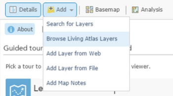
3. Easier to add Living Atlas layers
If you haven’t come across the Living Atlas layers before I encourage you to take a look and check out the brand new website for them. These are layers which Esri and the user community have made available to be used freely within the platform. These layers span over many different industries and can help give further spatial insight within the platform.

So how are these easier to use since the update?
Well now if you go to add data you will have the new option of ‘Browse Living Atlas Layers’. From here you can view all the different layers which are available to you and add them directly to your map.
As well as the layers there are also 3D web scenes to take a look at. You can view them here and there’s a blog giving you more information about them.
4. Custom print layout in the map viewer
Prior to the update when you went to print your map from the map viewer you only had one default print layout. Since the update administrators can configure the print layouts through the utility service setting.
5. Simple extruding of polygons in the scene viewer
Prior to the update you could extrude points and lines in the scene viewer, however, now you can also do the same for polygons. For example, if you have assets which are all the same height (i.e weather stations) you can put the height into the layer properties to see them in 3D. To try for yourself complete the following:
- Click the Symbols drop-down arrow Drop-down and choose Change symbols.
- Click the Type drop-down arrow Drop-down and choose 3D Extrusion.
- Click the Fill Colour drop-down arrow Drop-down to change the fill colour of your 3D polygons.
- Set the Transparency of the colour by entering a percentage value.
- Enter a positive value in meters if you want the Extrusion to go up vertically or a negative value if you want the Extrusion to go down.
- Click Done to go back to Contents.