There is a lot 3D development going on with esri software at moment, a part of which has led to the acquisition of a gaming company called Procedural (we’ve reported this in an earlier blog post). The software that Procedural developed is called CityEngine and it provides a rule base parametric modelling engine that allows you to build impressive 3D cityscapes in minutes. I’ve been lucky enough to get my hands on this piece of kit, and its fair to say that I’ve been blown away by its capability. In addition to CityEngine, I’ve also been able to test the new LiDAR tools available in the soon to be released ArcGIS 10.1. Its all very well having new and fancy 3D tools, but the question is, what does that really mean?
GIS has traditionally enabled informed decision making using complex spatial analytics. With the improvement in 3D tools, this analysis can be extended to 3D, for city planners, landscape designers, emergency services etc, to understand how 3D space affects decision making. In this blog post we will look at how we can use LiDAR data, CityEngine and the new 3D tools to make an informed decision about the design and construction of a hotel complex in Bristol.
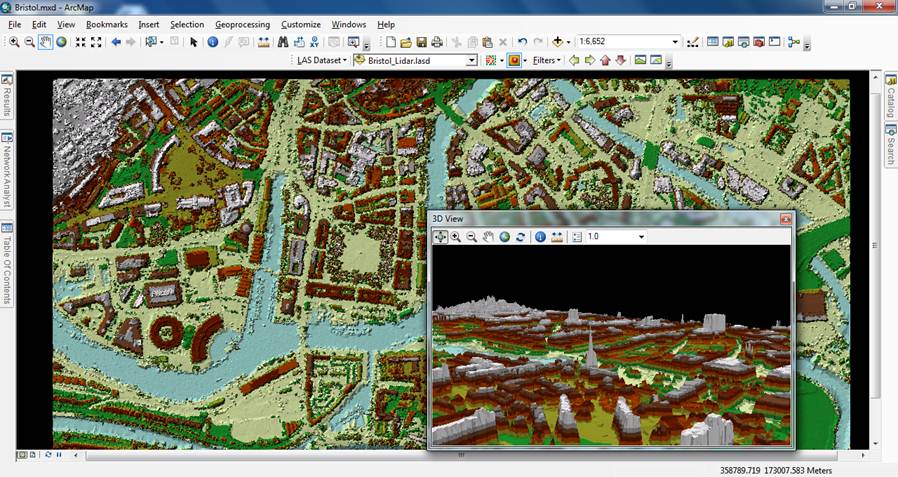
Our first task is to create an accurate 3D model of the surrounding buildings. This will allow us to see how our planned hotel will fit in with the neighbourhood and might flag up restrictions such as the height of the hotel based on the surrounding building heights. This is where we can use LiDAR data to help us out. LiDAR, for those of you who aren’t familiar, stands for (Light Detection and Ranging) and it is generated by a device emitting laser pulses at the ground to detect heights. Within ArcMap, we can use the new LiDAR tools to append the height values from the LiDAR data to our building footprints.
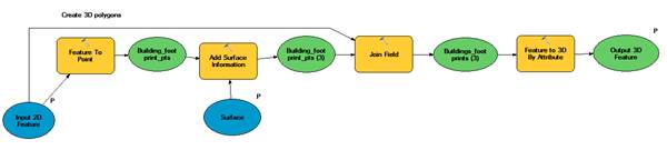
Model used to append heights to building footprint
Data sourced from BLOM
Now that we’ve got accurate heights for our buildings we can import this data into CityEngine and start creating our 3D models. The great thing about CityEngine is that it is really quick and easy to generate 3D content and allows you to create impressive visualisations of cities in seconds. All it requires is a set of ‘rules’ that describe how the GIS data is to be rendered within CityEngine. In this instance we’ve written a rule file which extrudes the buildings to the heights given by the LiDAR and also adds textures to give a good idea of what the area will look like.
However, we don’t just want a visualisation of the development; we want to do some powerful 3D analysis. Using ArcScene, we can perform different types of 3D analysis to aid our decision making process. In order to do this, we must first export these models into ArcScene. CityEngine provides us with a standard export function that allows export into a Collada data format (Collada is an industry standard format for display of 3D data). Within the ArcGIS 3D toolset, we’ve got an importer that then converts Collada into Multipatch (which the Esri standard format for analysing and managing 3D datasets). Once in multipatch format, you can then use the 3D tools to do some analysis.
The first thing I want to know is what shadow the proposed building might cast on the surrounding area. In order to do this, I can use the shadow analysis tool (new at version 10.1). We could also run a line of sight analysis to work out which rooms in the hotel will have ‘good’ views of the surrounding area. Perhaps, this could provide us with a metric to price the rooms accordingly (good views = more expensive?).
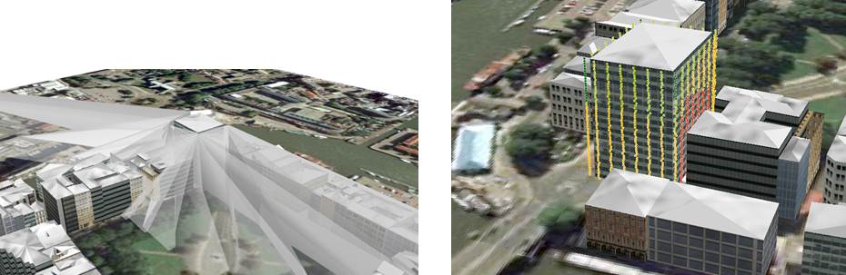
Shadow cast by planned building View from each room, where Green = good, Yellow = moderate, Red = poor
So as you can see, the new 3D tools working in unison provide great potential for not only analysing the world in 3D, but also being able to make informed decisions based on 3D analysis. The future is bright, the future is 3D.
Thank you to BLOM UK for supplying us with the LiDAR data that we used in this post.