Within ArcGIS Online you now get free access to five high quality basemaps for Great Britain called the OS Open Basemaps. They have been created using the latest Ordnance Survey Open Data products and enhanced for use within the ArcGIS Platform. The basemaps are an important addition to ArcGIS Online as they use the British National Grid (BNG) Projection system. If your data is also projected using BNG you will see an increased level of performance compared to the other WGS 1984 basemaps within the basemap gallery.
These basemaps are an exciting addition to ArcGIS Online and so I have written this post to highlight some of the important differences between each of them. To get you thinking about which basemap you could use and when, I have added guidance to help you make an informed decision about which basemap you should choose. Before we go any further let’s ask a few important questions about the data you wish to show:
- What is your intended audience and use for the map, what is relevant to the people using the map?
- What is your visual hierarchy? So is the basemap key to your map, or simply a backdrop?
In general basemaps are there for context and reference, not to draw attention away from the data on the map, however sometimes it may be key to have certain styling or colour schemes. I am, therefore, going to go through each of the basemaps so that you can ask yourself the above questions to each. To find out more about each of the basemaps use the links in the basemap titles or images below.
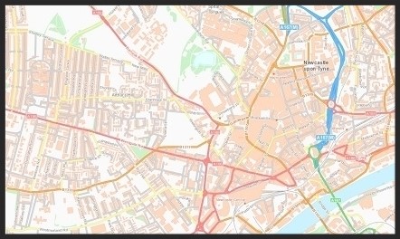
OS Open Carto
The OS Open Carto showcases classic OS cartography, using traditional and consistent colours which people are familiar with. This makes the geography easy to understand and read, making the basemaps ideal for navigation and pin pointing locations within the map. Due to the full colour representation you may need to think more carefully about the colour scheme of the data you wish to overlay so that your data doesn’t get lost in the level of detail of the basemap. For example, there is a chance that polygons and lines could get lost within the detail of the basemap, however with careful colour considerations the detail in this basemap could add a lot of geographical context to certain datasets
OS Open Background
This basemap is more subtle in colour compared to the OS Open Carto basemap but has more colour variation than the two grey basemaps listed below. As the basemap is a middle ground between the others, it is many peoples favourite. It has a consistent colour style, giving a low risk of colours clashing which leads itself well to thematic datasets. Large areas of vegetation and water bodies are given colour to differentiate them from other open spaces. This background mapping also has a high level of labelling detail at a large scale, giving a great deal of context for navigation purposes.
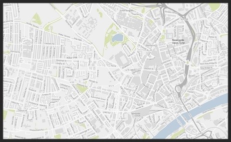
OS Open Greyscale Labels
The OS Open Greyscale basemap with labels, is a great backdrop basemap, due to its muted colours allowing attention to be drawn to your data when overlaid rather than the basemap. A good example of this is the lines and points which show the 2016 Marathon route in London. This basemap is similar to the OS Open Greyscale without labels, although the labels can be useful to add further geographic context and insight.

OS Open Grey
This basemap is a perfect muted grey backdrop to allow your thematic data to really ‘pop’ – with no distractions from the basemap or labels. It allows you to start with a blank canvas and build upon it. This is clearly shown by adding this polygon dataset which shows car emissions across the UK. The basemap gives geographical context to the dataset, as you know it is based in the UK, however it doesn’t distract from your data.

OS Open Rasters
The raster basemap provides a timeless background which people know and love. As you explore the map, the colour and styles vary depending upon the scale of the map. At a small scale the basemap shows off the topography and details of road networks. Then at a large scale the basemap is perfect for navigation, with features and roads being coloured and styled to distinguish them from each other. Due to the basemap not having a consistent style or colour, careful consideration may need to be taken when choosing which datasets and styles you wish to overlay.

Each of the basemaps are unique and have their own use cases behind them. This story map has also been produced to showcase the basemaps and highlight some of the features and differences of each.
So which basemap will you use…